NASA’s Earth Information System Delivers Analysis-Ready Fire, Freshwater, and Sea Level Change Products
Overview
NASA’s new Earth Information System (EIS) delivers analysis-ready products for use by scientists and non-scientists alike. The EIS consists of three pilot studies that leverage NASA’s Science Managed Cloud Environment (SMCE): 1) EIS-Fire, focusing on active fire and fire emissions data and supporting fire science and stakeholder needs for fire and air quality forecasting; 2) EIS-Freshwater, focusing on describing NASA water cycle science in a straightforward manner that appeals to a broad set of users; and 3) EIS-Sea Level Change, focusing on integrating models and observations to study the impacts of Greenland ice sheet melt on sea level change.
Project Details
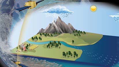
The EIS pilot studies assembled three teams with diverse scientific backgrounds, applied Open Science principles in a collaborative cloud environment, and took approaches informed by user needs. In the collaborative cloud environment supported by SMCE and JupyterHub, the team was able to develop and share data, modeling software, and visualization workflows.
Fire
EIS-Fire developed a visualization and analysis data portal providing access to a variety of fire data products in a cloud-optimized, analysis-ready format. The team also developed an algorithm for mapping active fire perimeters from satellite fire detections and updated the representation of fire emissions in the Goddard Earth Observing System (GEOS) model to use improved Visible Infrared Imaging Radiometer Suite (VIIRS) fire data. Finally, EIS-Fire engaged stakeholders in identifying use cases to inform data portal development.
The collaborative, Open Science environment used in the Earth Information System (EIS) studies was powered by cloud computing and analysis-ready data.
Freshwater
EIS-Freshwater enabled interactions between modeling, assimilation, analytics, and visualization capabilities for the Mississippi River basin. The project integrated observations of water cycle variables from various satellites within the NASA Land Information System (LIS) for quantifying surface and groundwater, hydrological forecasting, human management characterization, and studying hydrological extremes. EIS-Freshwater worked with federal partners, state agencies, and the private sector to broadly disseminate science products.
Sea Level
EIS-Sea Level Change focused on connecting process models to observational datasets, all hosted on the SMCE. The team implemented four models that simulate ice sheet surface processes, ice sheet flow, ocean circulation, and solid Earth adjustment to ice sheet mass change, demonstrating novel connections between the models and data enabled by the cloud-based collaboration environment. Additionally, the team prototyped an interactive tool that will ultimately be a public-facing tool hosted on NASA’s Sea Level Change portal.
Results and Impact
The collaborative, Open Science environment used in the EIS studies was powered by cloud computing and analysis-ready data. The project was enhanced by collaboration tools including JupyterHubs, GitLab, and ArcGIS StoryMaps to communicate information needed by scientists and non-scientists to understand, utilize, and build upon the scientific results. The scientific research produced by the EIS pilot studies was ultimately both open and accessible, which achieved the goal of this project.
Why HPC Matters
The NASA EIS project and the NASA SMCE are powered by Amazon Web Services (AWS), which offers two important advantages over traditional high-performance computing (HPC) resources. First, granting AWS access to users is significantly faster and more straightforward than granting access to NASA’s on-premise HPC resources, facilitating collaboration. Second, AWS offers a variety of flexible storage and compute options, facilitating identification of cost-effective solutions optimized for specific problems.
What's Next

The next phase of EIS will focus on maturation of approaches developed by NASA in the pilot studies, expanding the conceptual scope of all research activities, and bringing on new development partners and stakeholders. Over the next year, the three EIS science teams will strive to demonstrate the next level of scientific information, enabled by even more complex layers of multi-system analysis and model combinations. EIS-Freshwater will integrate data and models across the full water cycle. EIS-Sea-Level Change will connect process models to observation. EIS-Fire will use data and models to understand and predict fire impacts.
More Information
Researchers
- Christa Peters-Lidard, NASA Goddard Space Flight Center Please enable Javascript to see email address.
- Alexey Shiklomanov, NASA Goddard Space Flight Center Please enable Javascript to see email address.
- Sujay Kumar, NASA Goddard Space Flight Center Please enable Javascript to see email address.
- Denis Felikson, NASA Goddard Space Flight Center Please enable Javascript to see email address.