AI/ML/DL Benchmarks for Earth Science Applications
Overview
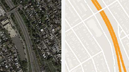
With the advancement of artificial intelligence (AI) technologies and the accumulation of big data from Earth-observing instruments, deep learning (DL) has become an important tool used by researchers to discover patterns and understand Earth science processes in greater depth. For example, DL models have been used to address critical yet difficult questions in the Earth science domain that include how to predict tropical cyclone intensity, how to detect rain clouds, and how to interpolate missing nitrogen dioxide. While successful in many areas, AI/DL applications are often computationally intensive. In recent years, graphics processing units (GPUs) have been leveraged to speed up AI/DL applications, yet computational performance still poses a major challenge. A team of researchers are systematically testing the readiness of GPU platforms for supporting various Earth science applications.
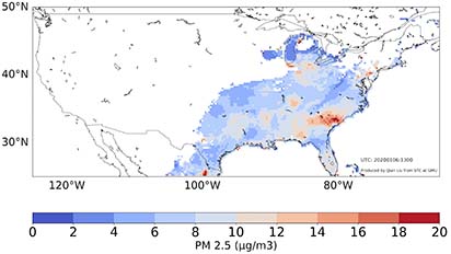
These benchmark tests proved that high-performance computing (HPC) provided by the NCCS Discover supercomputer’s GPU clusters can enable applications that include near-real-time processing of PM2.5; classifying high-spatial-resolution Arctic images; mapping based on satellite images; detecting clouds from satellite observations; and tracking public sentiment changes during different phases of a (natural) disaster.
Project Details
Researchers from the NASA Center for Climate Simulation (NCCS) at NASA's Goddard Space Flight Center and the National Science Foundation (NSF) Spatiotemporal Innovation Center (STC) at George Mason University investigated the technology challenges in computation-intensive Earth science research using AI/DL applications. The team addressed two benchmark tests in Phase 1 of this project: 1) comparing the performance of selected Earth science applications on popular platforms; and 2) utilizing GPUs to speed up AI/DL applications with a data parallelism strategy.
The team highlighted five sample Earth science AI applications, revised the DL-based models/algorithms, and tested the maturity level of GPU-supported computing platforms—such as Amazon Web Services (AWS), Google Colab, and the NCCS Discover supercomputer—for supporting state-of-the-art DL Earth science applications.
Results and Impact
The computing testbed aims to identify how mature a GPU-based computing infrastructure must be to support AI-based Earth science applications that use big data. Phase 1 tasks we accomplished include: 1) providing five Earth science AI/DL application packages with open-source code, operational tutorials, and video walkthroughs; 2) using several metrics such as runtime, hardware configuration, and accuracy to quantify application performance on GPU machines with different characteristics; 3) testing data parallelism strategies to speed up selected applications; and 4) drafting an initial report to summarize the research and results. These results can provide a better understanding of how GPU computing platforms can support Earth science applications.
Why HPC Matters
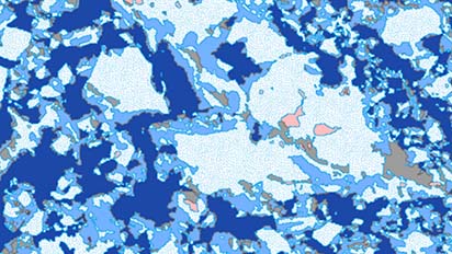
These benchmark tests prove that high-performance computing (HPC) provided by the NCCS Discover supercomputer’s GPU clusters can enable applications including near-real-time processing of PM2.5; classifying high-spatial-resolution Arctic images; mapping based on satellite images; detecting clouds from satellite observations; and tracking public sentiment changes during different phases of a (natural) disaster.
What's Next
Phase 2 will focus on optimizing GPU utilization. Specifically, we will 1) compare application performance on different platforms by adjusting hyperparameters such as training dataset size; 2) introduce to the testbed more Earth science applications using varied types of AI models such as graph neural networks; 3) implement and test different parallel strategies, such as model parallelism and pipeline parallelism; and 4) produce a comprehensive report to introduce the lessons learned in the testing process for benefiting the Earth science community.
More Information
- NCCS collaborates with the NSF Spatiotemporal Innovation Center at George Mason University
- Cloud Classification Application
- Daytime Rainy Cloud Detection and Convective Precipitation Delineation Based on a Deep Neural Network Method Using GOES-16 ABI Images
- Source code
- Satellite2Map Application
- PM2.5 Retrieval Application
- ArcCI Application
- Tweet classification application
Researchers
- Chaowei Yang, George Mason University Please enable Javascript to see email address.
- Daniel Duffy, NASA Goddard Space Flight Center Please enable Javascript to see email address.
- Yun Li, George Mason and Emory Universities Please enable Javascript to see email address.
- Michael Little, NASA Goddard Space Flight Center Please enable Javascript to see email address.