NASA Hydrological Forecast System for Food and Water Security Applications
Overview

The world’s drought- and flood-prone regions can experience higher frequencies of water and food insecurity, which greatly affect human lives. With global climate change impacts causing more intense droughts and floods, there is a growing need for early warning systems that can provide reliable and timely information to agencies and organizations providing humanitarian assistance to these regions. Government agencies, such as the U.S. Agency for International Development (USAID) and U.S. Department of Defense (DoD), rely upon the latest and most comprehensive data and analysis to best assess and respond to humanitarian, food, and water security crises.
To support these efforts, NASA Goddard Space Flight Center researchers developed the NASA Hydrological Forecast and Analysis System (NHyFAS). The FLDAS Forecast system, a custom instance of NHyFAS, produces monthly drought and flood potential monitoring and seasonal forecast products that are employed by food security analysts with USAID’s Famine Early Warning Systems Network (FEWS NET) and other end-users.
The NASA Hydrological Forecast and Analysis System (NHyFAS) … produces monthly drought and flood potential monitoring and seasonal forecast products that are employed by food security analysts with USAID’s Famine Early Warning Systems Network (FEWS NET) and other end-users.
Project Details
NHyFAS was built using NASA’s Land Information System Framework (LISF) software, with additional components from the University of California, Santa Barbara’s Climate Hazards Center. NHyFAS incorporates an ensemble of land surface models (LSMs) including NASA’s Catchment LSM, and the system is driven by NASA’s Goddard Earth Observing System (GEOS) seasonal forecasts. FLDAS Forecast was developed in 2019, adding precipitation forecast products from the North American Multi-Model Ensemble (NMME) project, increasing the ensemble size. USAID supports the FLDAS Forecast system by maintaining routine monitoring and forecasting products and analysis for FEWS NET. NHyFAS is currently being adapted for use by DoD partners.
Results and Impact
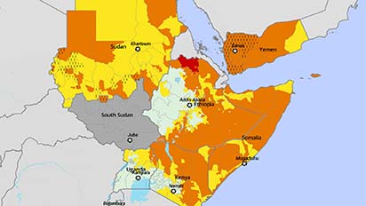
FEWS NET monthly food security assessments have incorporated FLDAS Forecast data and analysis since 2018, and the forecast products have helped agroclimatology analysts apply a “convergence of evidence”-based approach to see where greater predicted anomalies and more skill-based probabilistic forecasts may lie in relation to other data products and forecasts. This state-of-the-art hydrological forecasting system provides hydrological extreme estimates for drought and flood potential. A suite of products supports the evidence-based methods, including probabilistic agricultural drought forecasts and flood potential using streamflow forecasts.
Why HPC Matters
The NASA Center for Climate Simulation (NCCS) Discover supercomputer’s Haswell nodes have been used for 360 seasonal hindcasts of continental Africa from 1991–2020 and for forecasts starting from 2020 onward. Each model simulation utilizes 224 processor cores, totaling approximately a million processor cores for all runs to date. Runtime ranges from 2 to 6.5 hours, depending on the number of LSM ensemble members. For the FLDAS Forecast-based runs over Africa and the Middle East, Discover’s online disk stores about 40 terabytes of input data and 6.5 terabytes of output data.
What's Next
NASA’s seasonal hydrological forecasts will continue to be an important data source and tool for a variety of agencies and organizations within the U.S. and around the globe in monitoring and predicting extreme events. The next instance of NHyFAS—the LIS-Hydro Subseasonal to Seasonal (S2S) System—will assimilate NASA satellite products to help improve the forecast initial conditions, span the full globe, and extend forecasts out to 9 months.
More Information
- SC21 Virtual Presentation
- NASA Hydrological Forecast and Analysis System (NHyFAS) website
- Land Information System Framework (LISF) software
- NASA Hydrological Forecast System Supports Food and Water Security in Africa and Middle East
- The NASA Hydrological Forecast System for Food and Water Security Applications
- Improving Early Warning of Drought-Driven Food Insecurity in Southern Africa Using Operational Hydrological Monitoring and Forecasting Products
Researchers
- Kristi Arsenault, NASA Goddard Space Flight Center Please enable Javascript to see email address.
- Abheera Hazra, NASA Goddard Space Flight Center Please enable Javascript to see email address.
- Kimberly Slinski, NASA Goddard Space Flight Center Please enable Javascript to see email address.
- The Land Information System (LIS) Core Team, NASA Goddard Space Flight Center Please enable Javascript to see email address.